As Hawaii's coastline came into view from my window seat, it didn't take me long to identify the Big Island's tallest volcano, Mauna Kea. Capped in winter snow, the mountain rose almost 14,000 feet above sea level and defined the entire northeastern corner of Hawaii. (Back home, Arizona's highest peak is only 12,637 feet high.) Cloud cover and my seat's location prevented me from seeing the island's four other volcanoes: Kohala, Hualalai, Mauna Loa, and Kilauea, the last three of which are active.
Mauna Loa is the giant however, just a little lower in elevation than Mauna Kea but more than twice as massive in volume. The other three volcanoes barely compete in size: Hualalai is just over 8,000 feet and Kohala about 5,500 feet. Meanwhile, the most active of the volcanoes and the star attraction at Hawaii Volcanoes National Park, Kilauea, currently tops out at a mere 4,091 feet above sea level.
Kilauea and its siblings on all the Hawaiian Islands are shield volcanoes. They have wide, low profiles, resembling warriors' shields lying flat on the ground, rising gently to their crater-pitted summits. On quiet days they are much less glamourous subjects to behold than Mount Vesuvius in Italy or Popocatepetl in Mexico, for example, which as stratovolcanoes have much steeper, cone-shaped profiles. Nevertheless the possibility of getting close to hot lava was my siren call to visit the National Park for two nights.
Highway 11 is the southern route to the park, cutting between Kilauea's and Mauna Loa's summits after first passing close to the United States' southern most point at Ka Lae. I barely noticed I was gaining 4,000 feet and approaching Kilauea's apex because of the very gradual increase in elevation. There was also no definitive peak on the horizon, a characteristic of shield volcanoes but also a sign of the weather. I was entering a rain forest, so showers and low clouds obscuring my visibility were no surprise.
The National Park's entrance was on the summit and close to my destination, Kilauea Caldera, a crater that formed after magma (lava when it's underground) emptied following an eruption event centuries ago. Crater Rim Drive used to circle the caldera, but the road started closing in 2008, when Halema'uma'u Crater, situated within the far western zone of the caldera, re-erupted with a burst of earth-trembling destruction.
Craters are formed by the outward explosion of rocks and other materials from a volcano, while calderas are formed during the volcano's collapse. According to Hawaiian mythology, Halema'uma'u Crater is home to Pele, goddess of fire and volcanoes, and the creator of the Hawaiian archipelago.
The first English visitors to the region in the early nineteenth century observed the entire Kilauea Caldera, two miles long by one mile wide, as a raging lake of molten lava. Several decades later Mark Twain described a similar landscape as "a vision of hell and its angels." After another thirty years the caldera drained, with lava reemerging and receding only periodically in Halema'uma'u since then. However just in early January a dome fountain of lava, as high as sixteen feet and as wide as thirty, started filling the crater again. Albeit less stunningly, the lava was still erupting from the deep vent when I visited a month and a half later.
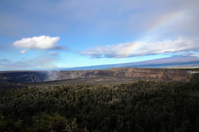
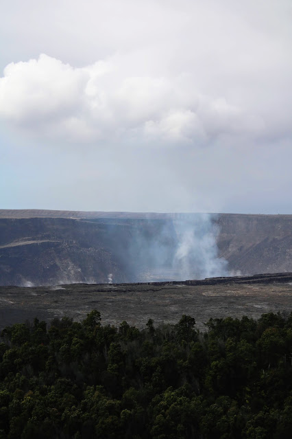
Alas, the view peering out over the caldera to the crater on a rainy afternoon from the Kilauea Overlook was a letdown: no lava lakes nor lava fountains to be seen, no fire nor devil, only a shadowy pit of billowing gases. This steam is mostly water but does contain carbon dioxide and sulfur dioxide, the latter especially toxic to life. That's why additional segments of the rim drive have recently closed and you can't actually peer close enough into Halema'uma'u to see hot lava: the discharging gas will kill you.
Sulfur dioxide combines with moisture on the island creating vog, or volcanic smog. Occasionally scientists need to broadcast alerts to local communities about the hazards, but the site of haze is frequently warning enough.
While I was way too late in history to witness what Mark Twain recounted one hundred and fifty years ago, I am almost old enough to have observed another spectacular event just beyond the eastern rim of the Caldera. In 1959, Kilauea Iki, a pit crater formed by a centuries-old collapse, was the site of a series of lava fountain eruptions. Over several weeks a fireworks display filled the sky and fiery currents and plumes of lava engulfed a blazing lakebed. A cinder cone of pyroclastic fragments above the now quiet vent and a flat crater floor are striking reminders of the spectacle sixty years later. Never one to miss a party, even if fifty years late, I hiked across the desolate landscape in 2009.
Further south and east in the National Park, as the wide shield volcano gradually slopes twenty miles and further into the Pacific Ocean, other craters and lava flows testify to much more recent volcanic events. Chain of Craters Road guides you through several of these massive late twentieth eruptions. In addition, beyond the park's borders are rift zones, cracks in regions of the volcano that regularly host eruptions on the flanks of the mountain.
The 2018 lower Puna eruption was one example, starting twenty-five miles away in Leilani Estates. It created 875 acres of new seafront land but not before destroying 700 houses that stood in the way of the flowing lava. Almost one house for every acre appeared to be Pele's demanding price for real estate.
Lots of steam, fascinating stories, colossal artifacts, crusted landscapes, but not a drop of hot lava. I had one more plan to get a glimpse of Pele and it didn't involve trespassing, helicopters, or time travel; it was night photography.
Hawaii Volcanoes National Park is open twenty-four hours a day so there's no problem driving to the overlooks and hiking the trails after sunset. Of course the nearby village of Volcano, where I was staying, averages 122 inches of rainfall a year, so weather was a potential hindrance. Fortunately the rain gods decided to play most of their mischief the previous night.
Nonetheless I trekked from the parking lot to Kilauea Overlook, currently the farthest you can drive along the Crater Rim Drive. A faint, reddish glow emanated from the western edge of the caldera and out of Halema'uma'u Crater, reflecting off the seething vapor and a perpetual overhead cloud. A long exposure shot might reveal something about Pele.
I wasn't traveling with a tripod, however a wide stone wall bordering the caldera's edge, a ruffled backpack, and a steady hand would do the trick. But first I had to remember everything I knew about amateur astrophotography: camera in manual mode, image stabilization off, ISO set at 6400, wide open aperture, autofocus off, manually focus on a distant street light in the parking lot, use the LCD display instead of the viewfinder. It was a lot to remember and execute in the dark. The couple of beers around dinnertime and the damp, blustery chill didn't help either.
After a few minutes of fumbles, I was finally capturing some four-second exposures that set an entirely new stage. An orange glow lit the crater's walls, the steam, and the lingering cloud overhead. The foreground was jet black, delineating the eerie precipice overlooking the fury simmering deep below. Cynical stars looked down on the millennia-young geology from thousands of light years away. I was pleased with the first captures. But even better, a ten second exposure taken later at a further away stop near Volcano House introduced into the mise-en-scène the lower slopes of Kilauea's approving big brother, Mauna Loa.
So did I actually see hot lava? No, but I got pretty darned close to a seething cauldron of it in a crater in a caldera on top of Kilauea. Between me and a thin new layer of Earth's crust was the volcanic hot spot that formed the Big Island and the entire chain of Hawaiian volcanoes and islands. While I hoped in vain to look into the face of Pele, all she offered this mortal was a glimpse at her eternal throne under his feet.
 |
| Ten-second exposure of Halema'uma'u Crater in Kilauea Caldera at night. Mauna Loa slopes upward to the right. |
 |
| Daytime view of previous shot of Halema'uma'u Crater in Kilauea Caldera. Mauna Loa slopes upward to the right. |
 |
| Wide daytime shot of Kilauea Caldera with Halema'uma'u Crater, left, and Mauna Loa rising to the right. |
 |
| Four-second nighttime shot of Halema'uma'u Crater in Kilauea Caldera. |
 |
| Four-second nighttime shot of Halema'uma'u Crater in Kilauea Caldera. |
 |
| View toward Halema'uma'u Crater. |
 |
| Kilauea Iki Crater, site of 1959 eruption, with cinder cone to left, and Kilauea Caldera and Halema'uma'u Crater behind. |
 |
| Hiker on Kilauea Iki Crater's hardened lava lakebed. |
 |
| Distant shot of steam resulting from lava reaching the Pacific Ocean from Kilauea's eastern rift zone, taken from the end of Chain of Craters Road in 2009. |
 |
| Lava from a 1980's flow blocking Chain of Craters Road, taken in 2009. |
 |
| Lava flow from a 1970's eruption along Chain of Craters Road, taken in 2009. |
 |
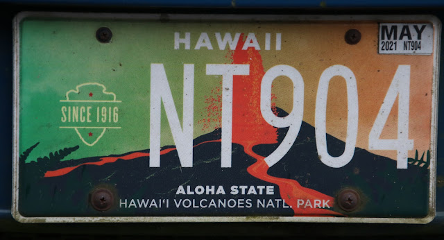
| License plate depicting a lava fountain and its flow. |
Comments
Post a Comment